")


Tekirdag, although located in the Ergene basin, has a sparse and limited river network due to insufficient vegetation, rainfall, and geological structure. The flow rates and regimes of the rivers are irregular and proportional to the amount and regime of rainfall. In summer, their waters decrease and they dry up, while in winter, they increase and even overflow with rainfall and snowmelt. The streams within the province's borders only carry rainwater and snowmelt. Furthermore, there are no sources feeding them. The province's rivers flow into the Gulf of Saros, the Sea of Marmara, and the Black Sea. The Ergene River and its tributaries, flowing east-west within the Ergene basin, are the most important rivers of the province. Originating in Güneşkaya near Saray, the Ergene flows southwest, joining the Corlu and Vize streams near Inanli village in Muratli, thus taking the name Ergene River. From the south, the Hayrabolu Cene (Besiktepe) streams join the Ergene River. After leaving the provincial borders, the Ergene River joins the Meric River near İpsala and empties its waters into the Gulf of Saros.
Although the Ergene River and its tributaries (Corlu-Hayrabolu stream) continuously retain water, their basins are narrow and the amount of water they carry is small. The streams located along the Marmara coastline do not have a continuous flow. They dry up in the summer. Short, weak streams empty their waters into the Marmara Sea. The main ones are Seymen Stream, Kumluca Stream, Serefli Stream, Degirmendere, Gazioglu Stream, Doganci Stream, Isiklar Stream, Olukbasi Stream and Golcuk Stream. Bahcekoy Stream, on the other hand, empties its water into the Black Sea.
However, the waters of the Ergene River flow cleanly only up to the Saray region. After that, it turns pitch black and becomes extremely toxic due to the waste from the industrial areas in Cerkezkoy and Corlu. The Corlu stream, which joins it in Muratli, is also extremely polluted and toxic. Therefore, the Ergene River cannot be used for irrigation purposes. In addition, after merging with the Meric River, its polluted waters also contaminate the Meric River.
Ergene River
The Ergene River originates in Karatepe, east of the Istranca Mountains. Flowing in a northeast-southwest direction, it irrigates the lands of Saray, Corlu, and Ergene districts. North of the Muratli district center, it receives the Corlu Stream from the south and begins to flow in a south-north direction, entering Kirklareli. Later, near Saricaali Village in Ipsala, Edirne, in the Hancagiz region, it joins the Meric River.Corlu Stream
The Corlu Stream originates in the Istranca Mountains east of Cerkezkoy; it flows northeast-southwest, receiving many small streams such as Pasa Deresi. After passing 5 km north of the Corlu district center, it receives the Marmaracik and Kutuklu streams. North of the Muratli district, it merges with the Ergene River. The stream's water level decreases significantly in summer and increases in winter due to rainfall. Furthermore, because all the waste from industrial facilities in the Corlu district flows into this stream, its water is polluted and toxic to an unusable degree. After merging with the Ergene, the pollution from both streams combines, making the water even more toxic.Hayrabolu Stream
The Hayrabolu Stream is one of the most important tributaries of the Ergene River. Flowing in a north-south direction, the stream passes through the Hayrabolu district center and joins the Ergene River in the north.Lights Stream
The Isiklar Stream, with one branch originating near Isiklar Village and the other near Nusratli Village, flows in two directions: the first branch flows south-north, and the second branch flows north-south. These two branches merge near Naipkoy. After a few kilometers, the Isiklar Stream flows into the Marmara Sea north of Kumbag.Olukbasi Stream
It originates from the Arapli Hills and flows southwest. Here it joins a small tributary. It carves steep and deep beds before reaching the coastal plain. Its speed decreases in the coastal section, and a bend is formed due to the slope. After passing the Sarkoy district center, it flows into the Marmara Sea.Golcuk Stream
The stream, originating from Isiklar Mountain, passes through Golcuk Village and turns west. After leaving the Tekirdag province, it takes the name Kavak Stream and flows into the Saroz Bay.Sea of Marmara
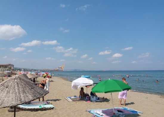
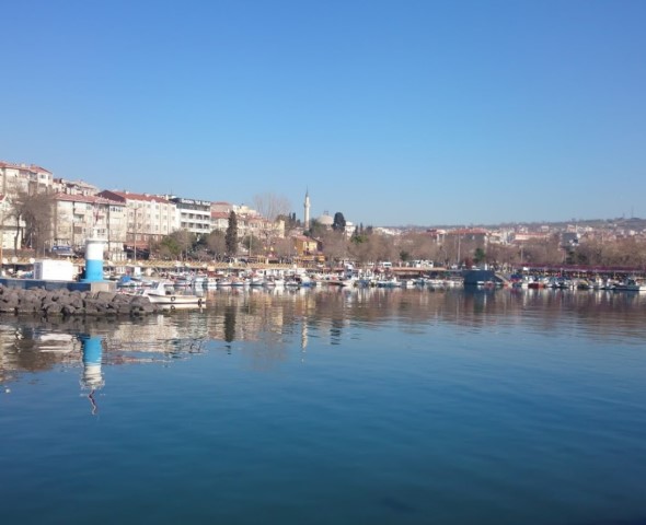
The sea was named Marmara in the 13th century due to the marble found on its islands. There are three large depressions in the Marmara Sea along the fault line connecting Izmit to Gazikoy. One is in the Izmit Gulf (1207 m), and the other two are south of Marmara Ereglisi (1355 m) and Kumbag (1070 m). The Tekirdag Gulf does not exceed 100 m in depth. It is a shallow sea called a shelf. It is rich in marine plants and animals. The gulf deepens to more than 1000 m south of a line drawn west from Kumbag. Fishermen call this a canal or 'com'. Schools of fish and the main currents pass through here. There are two rocky areas on the Marmara coast of Tekirdag province. One is west of the Marmara Ereglisi cape and very close to the sea surface. These rocks are resistant stones that have survived erosion. They are dangerous for vessels. There are lighthouses on them to mark their location. These rocks continue in a strip close to and parallel to the coast until they reach the front of Yeniciftlik village.
The second rock formation is located between Tekirdag and Barbaros. It is 5-10 m from the shore and runs parallel to it. Its depth is 0-1 m and its width averages about 5 m. Between the rocks and the shore, there is a sandy seabed with a depth of 0.3-0.7 m. The base of the rocks is a resistant sedimentary rock layer. It has been eroded down to below the water level. Its surface has been raised and thickened by the attachment of shellfish. In other words, the secretions of living marine animals and the shells of dead ones have fused with the sand, creating a second rock layer extending down to the water level.
The surface water temperature of the Marmara Sea is between 23-25°C in summer and 7-9°C in winter. After a depth of 220-350 m, the temperature remains constant at 14.2°C. Due to the surface current coming from the Black Sea, the salinity in the surface waters is lower than in the depths. The thickness of these low-salinity surface waters, with a salinity of 22‰, is approximately 15 m. Salinity increases rapidly in the depths, reaching 38.5‰ at 150 m. These highly saline waters at the bottom are the highly saline waters of the Mediterranean Sea carried by the bottom current.